


Grid to Contours
Purpose
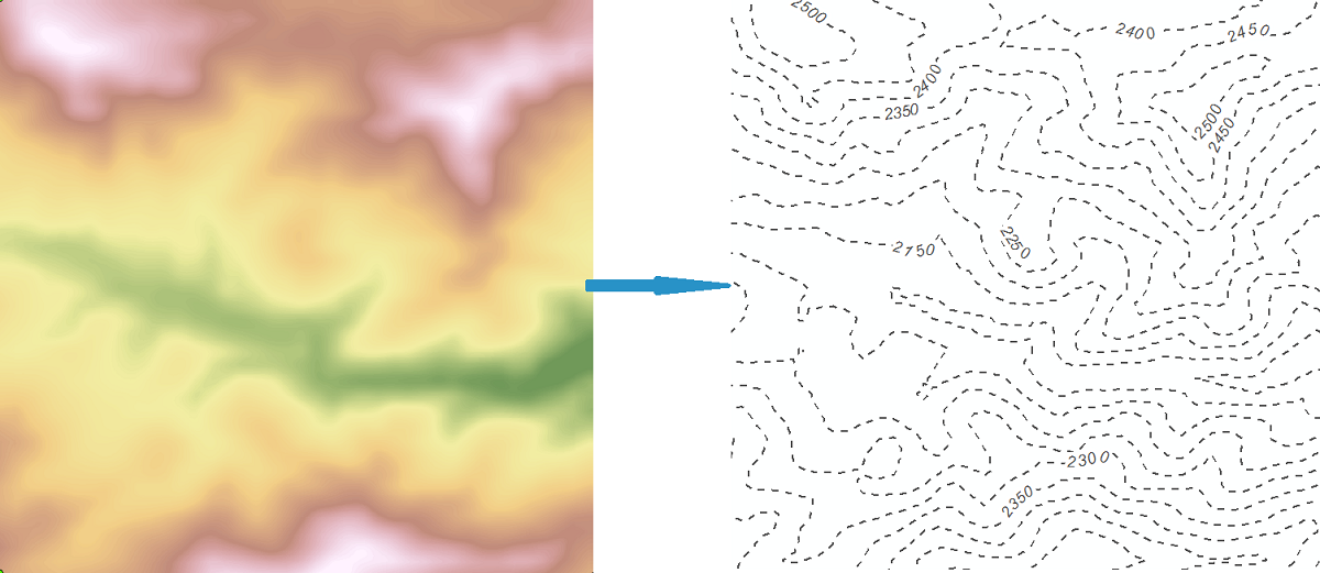
The purpose of the "Grid to Contours" tool is converting raster data models (grids) to contour polyline features (relief isolines, for example) with specified parameters.
Description
Contour is a line that typically connects points of equal elevation value on a terrain surface (an isoline). Grid is an opposite raster representation of geographic information. These two representations of geographic data are inter-convertible. Converting raster representation (Grid) is performed by defining contour parameters.
One Grid may have one or several bands. Band is a measure of a characteristic or quality of the features observed in a raster. Some rasters have a single band, others may have more than one. At that, only one band of a Grid can be converted to contours format in a single operation.
Usage
-
Select the "Grid to Contours" tool from the XTools Pro Surface Tools menu.
-
Select the input Grid/band to be converted to contours
-
Specify the name and location of the output feature class.
-
Specify contour definition parameters: contour interval, base contour, Z factor.
-
Specify output Z field and select if you wish to drop bounding contours.
-
Press Run to convert selected Grid to contours.
Contour definition parameters
For contour definition the following parameters should be determined:
-
Contour interval
The contour interval parameter is an interval between each two neighboring polylines in a contour representation that will be built. Default value of the contour interval is calculated taking into consideration that the number of contours between Z min and Z max values must be equal to the total contour value parameter, which is pre-defined and can be changed in the XTools Pro Options dialog. Changing the default contour interval value leads to the total contour values number recalculation.
-
Base contour
The base contour parameter determines the bottom bound of the contour representation. By default its value is equal to the value of the Z min parameter. Changing the default base contour leads to recalculation of the total contour values number.
-
Z factor
The Z Factor parameter is a Z scaling multiplier, which, being not equal to 1, changes Z ranging of a contour representation. The base contour, being multiplied the Z Factor, gives the Minimum contour (an output parameter). The Z max, being multiplied the Z Factor, gives the Maximum contour (an output parameter).
For your convenience, information about input height range (Z min and Z max) and output dataset (Min/Max contour values, Total number of contour values) is provided.
Bounding contours
Bounding contours can be dropped if not required. Bounding contours depend on the raster cells with NoData value.
Note:
If an error value is entered as one of the Contour definition parameters (contour interval, base contour, and Z factor), or one of these fields is empty this will be marked with a corresponding error.