


Show Area
#new
Purpose
The Show Area tool is provided for displaying area values of polygon features in the map.
Description
The tool allows displaying area values of the selected features. The value will be shown in the feature label point. Values can be displayed in different units. The tool is available for polygons only.
For multipart features the area values can be shown for the whole feature or for each component separately.
The following layer types are supported:
-
feature layers
-
selection layers
-
feature services
Usage
The Show Area tool is active if there is at least one polygon feature layer selected in the Table of Contents:
To display area values click the Show Area button from the XTools Pro toolbar, and values for all features of the selected layer will appear.
If there are selected features in the selected layer, values will be shown for the selected features only. Besides, values can be displayed for a few layers selected in the Table of Contents.
Working with multipart features
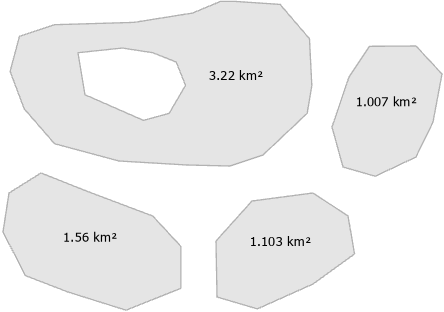
By default, area values for multipart features are shown for each component separately in its label points. Feature component may contain single or multiple parts (e.g. polygons with holes).
For feature components:
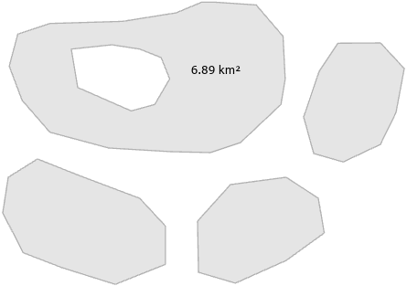
In XTools Pro Options you can uncheck the "Show area of feature components" option to view area values for the whole features. In this case, area value is located in the label point of the largest feature component.
For the whole feature:
Please note that if the feature is just displayed partially in the map current extent, its area value is always shown in the label point of its visible part.
Showing area values in different units
By default, area values are shown in units of selected layer datasources spatial reference. However, you can select an active map coordinate system or specify custom projected coordinate system and linear units (see XTools Pro Options). Hectares, ares, acres are also available to be selected.
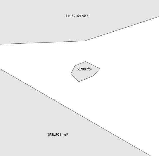
You can specify fixed units to show all area values in the same units. At that, If selected features are of different size, you can choose adaptive metric or imperial units. In this case, displayed units are dynamically adapted to the feature size.
For example, adaptive imperial units:
Note
-
Selected feature layers won't be re-projected, specified coordinate system and units are only used for calculating and showing area values.
-
Units for geographic and unknown coordinate systems won't be displayed.
-
Selected geographic or unknown coordinate systems aren't matched with specified linear units. In this case, area values cannot be shown.
Viewing options
Displayed values are represented with graphic text symbols. Text font size and color, count of decimal places can be customized (see XTools Pro Options).
Note
-
Displayed values are fixed between refreshes or Zooms/Pans and shown until turned off.
-
Feature editing is not required.
Turning off values
To turn off area values in the map click again the Show Area button from the XTools Pro toolbar.