Square Off Polygons
Purpose
|
Input feature types: |
|
|
Output feature types: |
|

The tool is provided for bringing the polygons’ angles to the 90 degrees value. All angles in polygons that are less than the permissible deviation value will be squared off.
|
Input feature |
|
Output feature |
|
|
→ |
|
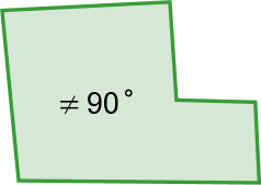
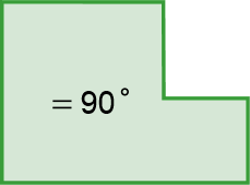
The main purpose of the tool is squaring angles in buildings. If while digitizing the polygons have been drawn with the right angle creation option disabled, the Square Off Polygons tool may appear a perfect solution to fix such polygons.
For output data, it is possible to specify one of spatial reference options: input data, data frame, map layer or spatial reference from the list.
Specifying angles deviation value
In order to avoid squaring of all the angles, there is an option to specify the maximum permissible deviation from the right angle - d.
For example, if your polygons represent buildings, you can filter out those angles that are the architectural particularities and so to skip them while processing.
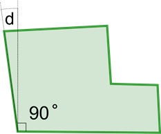
The maximum permissible deviation from the right angle may vary from 1 to 44 degrees.
Attributes configuring
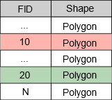
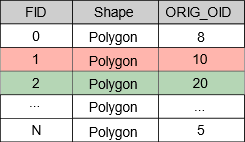
The tool allows transferring the input features IDs to features of the output layers. This ID may be used for setting up the correspondence between input and output features.
To transfer the ID, the Field ID option should be enabled.
|
Input attributes |
Output attributes |
|
|
|