


Polygons from Points
Purpose
Input features: 
Output features: 
The tool allows converting points from the point layer to one or multiple polygons.
Description
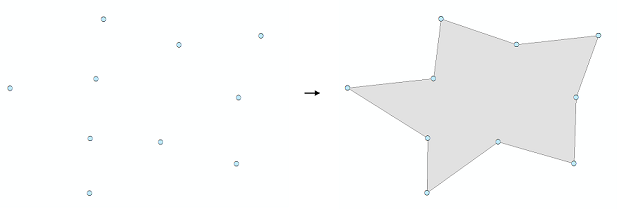
Based on the input set of points, the tool creates one or more polygons of the smallest area without self-intersections. Resulting polygons can be saved in a new shapefile or as a geodatabase feature class.
Options
The following options are available in this tool:
-
Use selected features
Allows processing selected features only
-
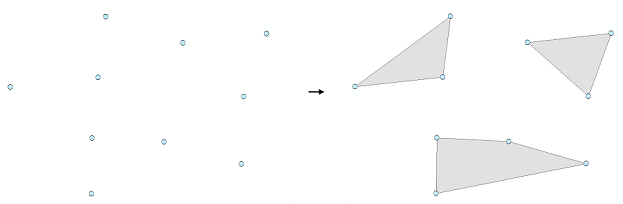
Group by field
Allows the user to create multiple polygons by selecting the field by which the input features will be grouped
-
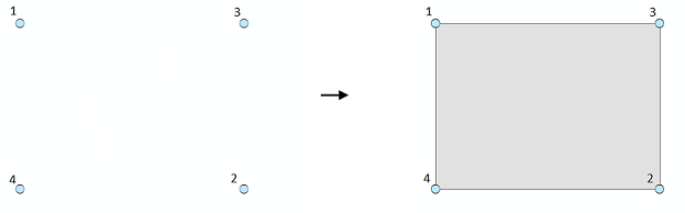
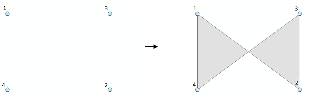
Sort by field
Allows the user to apply the order of input points when creating a polygon (polygons)
This option can be used if the order of the input objects is known and needs to be considered. By default, no field is selected. The order can be specified, for example, by the FID field (this will set the order in which the points were digitized), or by other attribute field.
The field for ordering is not selected:
Sort by OID field:
-
Tolerance
Allows you to set the minimum distance within which the coordinates of the points are considered distinguishable
Usage
-
Select the "Polygons from Points" tool from the Conversion tools of XTools Pro menu.
-
Select the input layer containing points that you wish to convert to polygons using Map Content, Catalog, History or Favorites.
-
Specify the name and location of the output feature class using Catalog, Default Path, Document locations, Home GDB, History or Favorites. The output data can be saved in a shapefile or in a geodatabase.
-
Specify the tolerance and the fields for grouping and ordering if required.
-
Press Run to convert points to polygons.
Note
Multipoint features cannot be used as input data.