Calculate Polygon Width
Purpose
|
Input features: |
|
|
Output features: |
|


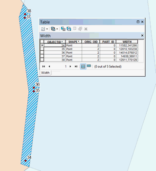
The XTools Pro Calculate Polygon Width tool is provided to calculate widths of polygon features. The result of the tool work is the point feature class created based on the polygon layer, where each point is the node of the polygon center line. The calculated polygon width at the specified point is written to the attribute table of the output point feature class.
Description
When calculating the polygon width, the tool first calculates the center line of the polygon, then extracts nodes from this line, after that calculates distances to the polygon border, and then writes the result to the point feature class. Since center lines of complex polygons may consist of several parts, the ID and the part number of center lines are written to the attribute table of the output feature class in addition to polygon width values.
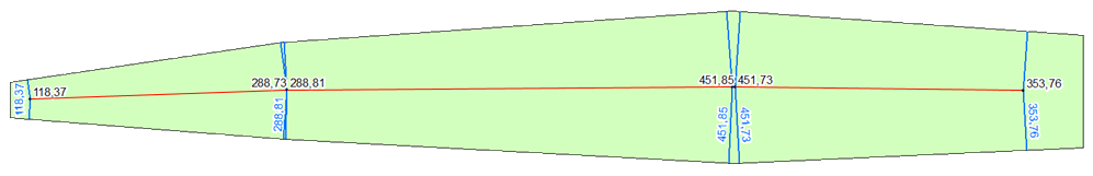
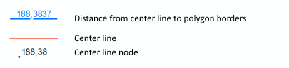
In terms of this tool, the polygon width is the sum of shortest distances from the center line nodes to the polygon borders.
The Calculate Polygon Width tool can be run from the Analysis Tools section of the New menu or from the Conversion Tools section of the Classic menu.
Usage
To calculate width of polygon features, the following parameters should be specified:
-
Input features - these are polygon feature classes. If there are selected features in the input polygon layer, the width will be calculated for those selected features only.
-
Output feature class - this parameter specifies the point feature class whereto the polygon width values will be added.
-
Point attributes - this parameter allows adding fields with parameters defining the point inside the polygon and located on its center line:
-
Width - the field containing the polygon width at the point. The width is the sum of two shortest distances from the center line point to the polygon borders. The default WIDTH field name can be changed if needed.
-
Polygon ID - the field in the attribute table of the output dataset containing ID of input features. The default ORIG_OID field name can be changed if needed.
-
Part number - the field containing the sequence number of the center line branch. The default PART_ID field name can be changed if needed.
Output point features with calculated width values can be used to find minimum, maximum values, and obtain other statistical values using the standard ArcGIS means. That is, you can locate places with specific value on the map. For example, using the search request you can find and display points within specified width range, or points where polygon width is more than specified distance etc.
The Calculate Polygon Width tool can be used for solving tasks where analysis of polygon features widths is needed, for example, if you need to find area of flood zones, width of the overlapping area of land allotments, size of zones of negative environmental impact, size of geologic objects on the map or in the cross section.
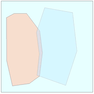
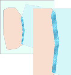
Example: calculate width of the overlapping area of two polygons.
The overlapping polygons:
First, we can find the overlapping zone using the standard ArcGIS Clip tool:
Then, we can use the Calculate Polygon Width tool to get the center line nodes with the calculated width of the overlapping area: