


Random Sampling Points
#updated
Purpose
The Random Sampling Points tool is provided for creating randomly distributed points within the specified extent.
Description
The tool creates new point dataset within the specified extent with specified type of points sampling and number of points.
The coordinate system of the output points is specified based on coordinate system of the data frame. That is, if you select to create random sampling points by constraining features of specified layer, the output data will be in coordinate system of this constraining layer.
All the specified parameters will be applied to the output random sampling points, at that note that in some cases (when contradictory conditions used) the points might not be created.
For example, if no more random sampling points can be generated within the specified constraining area without breach of minimum distance between points, the number of the output sampling points in the constraining area will be reduced to minimum possible within minimum acceptable distance.
The Random Sampling Points tool can be run from the Analysis Tools section of the New menu or from the Data Tools section of the Classic menu.
Usage
To create random sampling points, the following parameters should be specified:
-
Output feature class – specify feature class for the output points. The output data can be saved as shapefile or as a geodatabase feature class.
-
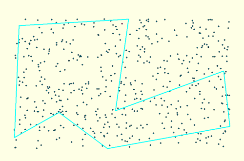
Constraints – constraint parameters for the output sampling points can be specified by extent or by features.
-
Extent – constraining extent for the output sampling points can be:
- Random extent – you can specify set of maximum and minimum values for x, y coordinates.
- Full extent – extent of all map layers.
- Current extent – extent of visible area of the map.
- Layer or dataset – the input data can be added from Map content, Catalog, History or Favorites of XTools Pro. The sampling points will be created in the area constrained by the extent of the whole specified layer. If the constraining layer contains selected features, the points will be created in the extent of the selected features only.
- Graphics – sampling points will be created
in the extent of graphic features of the map only.
- Selected graphics – sampling points will be created in the area constrained
by the extent of selected graphic features.
-
Features — this constraint can be either point, polyline, or polygon feature layer. The input features can be added from Map content, Catalog, History or Favorites of XTools Pro. The new random sampling points will be created by the specified points, along the constraining polylines or within the constraining polygons, accordingly.
-
Type of sampling – this parameter determines the type of filling the constraining features with the sampling points. The following sampling variants are available:
-
Random — sampling type when constraining features are randomly filled with the points.
-
Quasi-random — sampling type when constraining features are filled with the points not randomly, but by a regular grid. The sampling randomization level (in this case it is the regularity deviation level) is specified in percent from 0 to 100. That is, at 0% the points are distributed by the regular grid. Higher sampling randomization level results in higher deviation from the regularity level. At 100% the regularity of sampling points is not visible.
-
Number of points can be specified as a constant value or based on the values of selected field of the constraining polyline or polygon layer, in this case for each constraining feature there will be generated as many points as given in the selected field for this feature.
The number of points can be:
- Total number of points – if constraining point layer selected or no constraining
layer selected.
- Maximum per feature – if constraining polyline or polygon layer selected.
- Percentage from feature count – if constraining point layer selected.
-
Minimum distance – optional parameter. If minimum distance is specified, the output sampling points will be generated at this minimum distance from each other.
The minimum distance can be specified as a constant value or based on the values of selected field of the constraining layer.
By default, the last used units for minimum distance are taken, but other measurement units can be used if needed.
-
Excluding features – optional parameter. The output random points won't be created at the points, on the polylines or within polygons of the selected excluding feature class.
When creating random sampling points, all possible conditions, or any combination of them can be applied. At that, it is obviously not allowed to use the same feature layer as the constraining and excluding layer as there is nothing to output in this case. On the other hand, other conditions may also contradict each other. These contradicted conditions may result in slower performance or no output. However, to ensure the workflow flexibility, such conditions are not prohibited and remain at the user's discretion.