


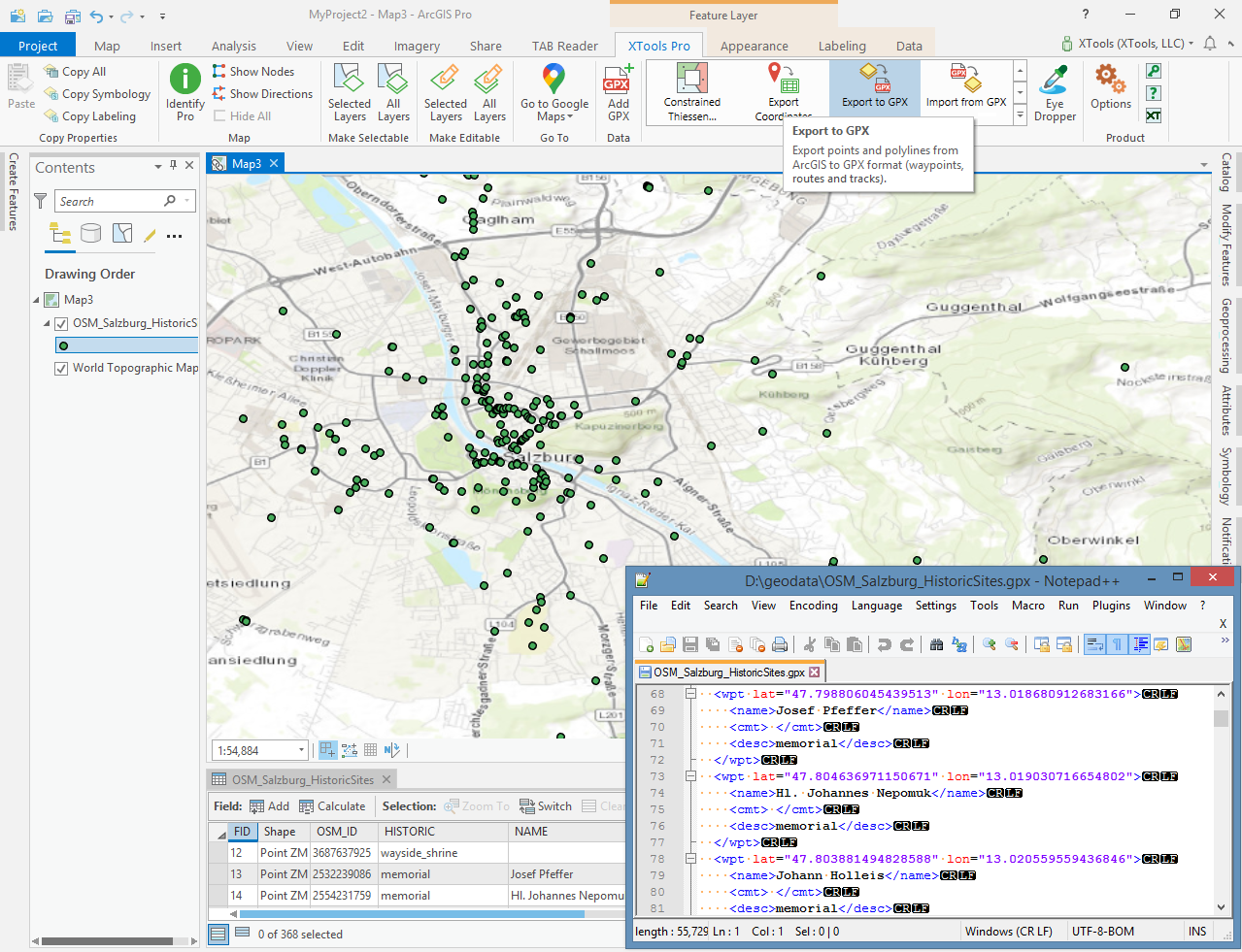
Export to GPX
Purpose
A tool is provided for exporting datasets from ArcGIS to GPX format (waypoints, routes and tracks). Exported GPX files can be used with the different desktop or mobile applications and online services.
Description
XTools Pro Export to GPX tool allows exporting point, polyline and polygon features from shapefiles or geodatabases to GPX file (version 1.1). You can select input fields for some of GPX attributes. At that you may manage the Time attribute values (specifying input time zone for input Time field values or setting "zero date" as timestamps for all points in output GPX).
Usage
-
Select the "Export to GPX" tool from the XTools Pro Import\Export tools.
-
Select the input dataset containing features that you wish to export.
-
Specify the name and location of the output GPX file.
-
Select output GPX data type.
-
Select the attributes you wish to export to GPX and select applicable input attribute field for each selected attribute.
-
Select if you wish to keep additional attributes including extensions that can be recorded in the output GPX file.
-
Select input time zone to output Time attribute in UTC +00:00.
-
Select "Zero date" option if you wish to record 1970-01-01T00:00:00Z to GPX time attribute for all points.
-
Press Run to export data to GPX.
By default output GPX file will be located in the current project folder.
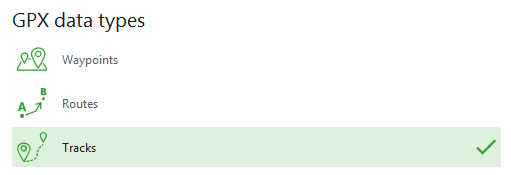
Specifying output GPX data type
Input points, polylines and polygons can be exported as one of GPX data types:
-
Waypoints - input points will be exported to output GPX file as waypoints.
-
Routes (with route points) - input features will be exported to output GPX file as routes with route points. All points will be exported as route points in a single route. Each polyline, or polygon feature (and also multipart feature) will be a unbroken separate route with the feature nodes as route points.
-
Tracks (with track points) - input features will be exported to output GPX file as tracks with track points. All points will be exported as track points of a single track segment in a single track. Each polyline, or polygon feature will be a separate track with the feature parts as track segments and feature nodes as track points.
By default output GPX data type is Waypoints for input point features and Tracks for input polyline and polygon features.
Notes:
-
If input point dataset has Route ID field, Routes are selected by default as output GPX data type.
-
If input point dataset has Track ID field and Track Segment ID field, Tracks are selected by default as output GPX data type.
Exporting attributes
Exporting data to GPX file you can select attributes that will be added to the output file:
-
Name
-
Description
-
Comment
-
Symbol
-
Time
-
Elevation
For each selected attribute the applicable input field should be selected from the drop-down list. If input dataset has fields with the same name as GPX attributes, these fields for these attributes will be selected by default.
Note:
Elevation attribute value can be specified only from numeric input attribute field, not from Shape field.
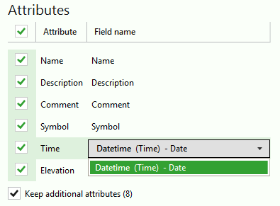
You can select to keep all additional attributes that can be in the input dataset attribute table. Applicable input fields count is shown in brackets. Only input fields with the same names as GPX attributes (including supported extensions) are taken into account.
Optional attributes that can be added are:
for waypoints, route points, track points:
-
MagVar - magnetic variation (in degrees)
-
GeoidHgt - geoid height (in meters)
-
Source
-
Link - links
-
Type - type (classification) of the point
-
Fix - type of GPX fix
-
SatNum - number of satellites
-
Hdop - horizontal dilution of precision
-
Vdop - vertical dilution of precision
-
Pdop - position dillution of precision
-
AgeOfDgps - number of seconds since last DGPS update (DGPS data age)
-
DgpsID - ID of DGPS station used in differential correction
for routes and tracks lines:
-
Source
-
Link - links
-
Number - GPS route/track number
-
Type - type (classification) of the route/track
Besides, following extensions with their attributes are supported:
-
GARMIN GPX Extensions v2
-
GARMIN GPX Extensions v3
-
GARMIN Waypoint Extensions v1
-
GARMIN Trackpoint Extensions v1
-
GARMIN Trackpoint Extensions v2
Note:
If selected input field is empty, this attribute won't be added to the output GPX file.
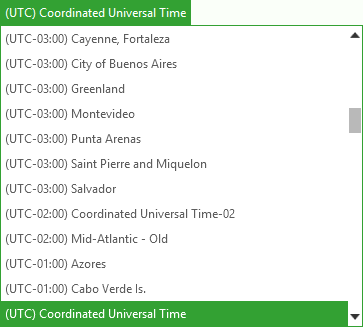
Selecting input time zone
Timestamps should be recorded in Coordinated Universal Time (UTC +00:00) in the output GPX file. If input Time field values is in another time zone, you can select the input time zone from the drop-down menu.
If Time attribute is not selected, this option is disabled.
Setting "Zero date"
If you need to record timestamps to the output GPX file, but input dataset doesn't have the Time field or the selected input field value for Time attribute is incorrect or missing, you can select the option "Zero date" to record 1970-01-01T00:00:00Z as time attribute value for all points in output GPX file.
This option is enabled if Time attribute is not selected or not available (for polyline and polygon input features).