


Rename Multiple Datasets
Purpose
The tool allows to rename multiple datasets in ArcGIS Pro easier and faster than you might realize it using capabilities available with ArcGIS Pro without XTools Pro.
There are numerous and countless scenarios that can be foreseen and that are now addressed and supported: modifying names adding characters, adding counters, replacing parts of names, replacing datasets names with their layer names, adding geometry types to the datasets names and a lot more. All that now can be easily and promptly done (and undone, if required) with XTools Pro.
Description
The Rename Multiple Datasets tool is aimed to help you with changing names of your ArcGIS datasets providing multiple advanced options and masks.
This is not a conversion tool so the extensions are not altered, all the work is made with the datasets names.
Following types of data are supported:
-
Shapefiles
-
Geodatabase feature datasets (also including ParcelFabric), feature classes (also including dimensions, network datasets, topology, terrains), tables
-
Raster datasets and its bands
-
LAS-files
-
Annotations
-
Relationship classes
-
Sheets of XLS, XLSX-files
Renaming multiple datasets
The tool is available from the Data Tools menu, no matter if there is a map open or any data currently added in Map.
The tool dialog window consists of the following main parts:
-
Rename mask field
-
Buttons allowing to add renaming components
-
List of datasets for renaming
Datasets to rename can be added with an Add Data dialog using the button on the right.
Note:
Joins of the added dataset layer will be missed after renaming.
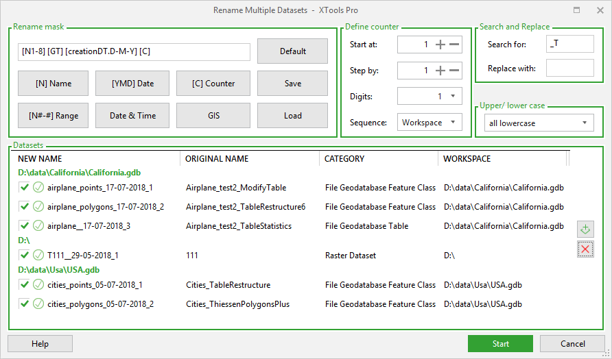
Rename mask components
Rename mask may consist of:
-
[N] Name - contains original dataset name, this is the default mask
-
[N#-#] Range - contains specified range of letters from original dataset name
-
[YMD] Date - contains creation date of original dataset in YMD format
-
Date & Time... - this can be either creation date and time or current date and time in various formats and combinations
-
[C] Counter - contains a counter for the selected datasets. Counter properties can be defined using separate controls on the right.
-
GIS... - this can be [GT] geometry type, [GDB] geodatabase name (supported only for file and personal geodatabases), [SR...] spatial reference or [U...] units.
Renaming components can be added using buttons or entered manually.
Rename masks can be saved and loaded for use later in another renaming sessions.
Note
-
Everything you enter in the rename mask is case sensitive.
-
The letter "T" will be added to the left of the name that begins from a number.
-
All spaces or other special characters in the name will be replaced with symbol "_".
-
New name for raster datasets can be less than 13 symbols for one-band raster or less than 9 symbols for multi-band raster.
-
Using Delete button on the right you can remove only highlighted datasets from the list for renaming.
Other options
Defining counters
Using counters in renaming mask you can change and specify the start number, increasing step, number of digits and also the sequence for the counter.
Search and replace
Renaming datasets you can search and replace certain letters/numbers or combination of them in the input names.
Changing names case
Changing case without actually changing the original names is only possible for shapefiles.
Renaming summary
For the renamed datasets there is a renaming summary provided where you can see what layers successfully renamed and what layers failed.
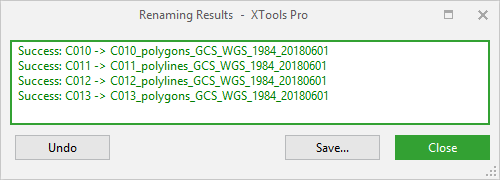
For the renamed datasets you can:
-
Save results summary to file (.txt or .rtf)
-
Undo renaming for all renamed datasets